Tag: VTS
System Administrator (m/f/d) with focus Windows and IT security
A new era for port operations in Scheveningen
On May 21st, the City of The Hague officially inaugurated the new Harbour Authority & Control Centre in Scheveningen – a major step forward in the city’s maritime infrastructure and igital transformation.
Strategically located at the northern harbour head, the new facility is designed to enhance the coordination of vessel traffic, urban mobility systems and port infrastructure. The building’s architecture, inspired by the shape of a ship’s wheelhouse, brings together tradition and innovation while offering panoramic views of the sea and the port entrance.
IN is proud to have contributed to this milestone by providing the VTS system used at the new control centre. Our solution supports the real-time monitoring and coordination of maritime traffic entering and leaving the port of Scheveningen, as well as operations related to the nearby offshore wind farm and offshore substation. The system provides operators with a comprehensive, integrated overview of vessel movements – enhancing safety, efficiency and situational awareness.
We were honoured to be invited to the official opening of the building and would like to thank the City of The Hague for including us in this important moment. It was a valuable opportunity to see how our technology is being used in practice and to witness the city’s commitment to modern, connected port operations.
The new control centre replaces the former facility, which no longer met the operational and spatial requirements of modern port management. In addition to maritime traffic services, the new site integrates the control of tunnels, bridges and access routes throughout The Hague, including the Victory Boogie Woogie Tunnel, opened in 2021.
With its increased capacity and technical capabilities, the control centre now brings together harbour authority personnel and infrastructure monitoring teams under one roof. A meeting space for retired fishermen has also been included, preserving a connection to the area’s seafaring history.
We thank the City of The Hague and all project partners for the opportunity to support this forward-looking initiative. The new Harbour Authority & Control Centre marks a significant advancement in secure, efficient and integrated port operations.
IN joins the German Association for Marine Technology
IN is now a member of the Association for Marine Technology (GMT). The GMT is a non-profit organisation that has been in existence since 1983 and represents the interests of companies and research institutions in the field of maritime technology to the public and political decision-makers throughout Germany.
The membership offers IN access to an established network of business and science. The aim is to promote the exchange of information on latest technical, economic and political developments, to initiate joint innovation projects and to support the development of new national and international markets.
As a provider of solutions for maritime monitoring systems, IN contributes specific technical expertise to the network. Participation in topic-related working groups and events such as ‘Meet the Members’ or the monthly Maritime Gathering provides additional impulses for expanding the professional exchange.
By joining the GMT, IN is emphasising its long-term commitment to marine technologies and its aspiration to actively contribute to shaping and developing the industry.
Member of the Bundestag Dieter Janecek presents funding certificates for the SeaSentry research project
At SMM 2024 in Hamburg, Dieter Janecek, Member of the German Parliament and Coordinator of the Federal Government for Maritime Economy and Tourism, visited the booth of in-innovative navigation GmbH. With warm congratulations, he handed over the funding certificates for the SeaSentry research project, emphasizing its significance for maritime safety.
The SeaSentry project aims to develop a real-time, land-based vessel tracking system that contributes to enhanced maritime safety. At its core is a sensor network that passively detects signals from ship radar systems without requiring any additional installations on board. This innovative technology will be seamlessly integrated into existing VTS systems to improve safety and efficiency in complex maritime environments.
The project is being carried out in collaboration with Covadonga GmbH, Knowtion GmbH, the Otto-von-Guericke-University Magdeburg, the DLR Institute for Systems Engineering for Future Mobility, and in-innovative navigation GmbH. Together, these partners are working on developing and testing the sensor technology to optimize maritime surveillance and deliver significant added value for users.
inDTS is now S-100 ready!
At this year’s EUROPORT, we took the chance to showcase the integration of SevenCs’ state-of-the-art S-100 Nautilus ECDIS kernel into our inDTS application for the first time. We have had a long and fruitful cooperation with SevenCs for over 20 years. We are pleased that with inDTS and Nautilus we can combine two powerful tools into one comprehensive and highly performant maritime traffic monitoring solution.
The integration of bathymetry data, for example, provides our customers with a wealth of new information. The availability of this data is essential for the precise planning and execution of dredging work, e.g. in harbor areas or river sections that depend on draught. It is therefore crucial to carry out such work, for example, to remove washed-up sand from canals or berths to ensure the required water depths. If this bathymetry data is also available in a highly up-to-date condition, harbor operators can plan the use of berths in an even more targeted manner.
Thanks to the cooperation with SevenCs and the regular exchange and participation in the relevant standardisation committees (e.g. IALA VTS Working Groups), we are ideally positioned not only to meet current standards such as S-124 “Navigational Warnings” or S-125 “Marine Aids to Navigation (AtoN)”, but also to smoothly integrate future standards of the S-100 framework. Examples of this are the standards S-210 “Inter-VTS Exchange Format”, S-211 “Port Call Message Format” and S-212 “VTS Digital Service”.
This advanced co-operation enables us to meet the constantly growing requirements of the maritime industry and at the same time to provide innovative solutions that continuously improve efficiency and security in VTS systems.
Handover of a modern maritime simulator to the Water Police School in Hamburg
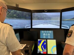
At the beginning of May 2023, the new ship navigation simulator was handed over to the Water Police School (WSPS) in Hamburg for training purposes. With this order, the long-standing successful cooperation between the WSPS and in-innovative navigation GmbH (IN) was continued and IN’s expertise in the supply of high-quality ship and VTS simulators was once again proven.
The new ship driving simulator (FaSi) consists of three NAUTIS bridge simulators, two instructor stations and a debriefing station for lesson evaluation. The simulator can be used to impart expertise for the professional maritime education and training of water police officers.
An essential component is the realistic simulation of possible operational areas in inland and maritime areas. The WSPS can access a fleet of different training vessels as part of the extensive training courses.
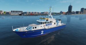
Five customized ship models of existing police boats were developed for the WSPS.
Model Ship – Coastal Patrol Boat
The simulation of the training vessel takes into account various influencing factors such as shallow water effects, wind, current, ship-ship interactions, channel effects or lock effects.
Fatih Şenel, project manager at in-innovative navigation GmbH, is satisfied with the result: “Within a few months we were able to successfully implement the many and demanding requirements as well as the specific needs for the teaching purpose. The radar and driving simulator combines an arsenal of functions that are a unique selling point for the training and teaching mission of the WSPS. With the simulator, the new WSPS building is more than equipped for the future in terms of teaching technology.”
Olaf Hagenloch, Head of Training at the WSPS, is looking forward to the integration of the simulator into the teaching at the WSPS: “With this simulator, the Water Police School will once again fulfil its mission to provide the officers of the water police from 15 federal states with the necessary qualifications. With this simulator, the WSPS will also be equipped for future training and further education needs, so that the colleagues can act at ‘eye level with the shipping industry’. With this simulator, we are taking another big step towards generation-appropriate learning in modern education and training. Within the framework of the project, the already proven cooperation with in-innovative navigation GmbH was confirmed again.”
The FaSi complies with the European Standards of Technical and Functional Requirements for Driving and Radar Simulators in Inland Navigation (ES-QIN).
The partner for the realization of the project is the Dutch company VSTEP from Rotterdam.
We wish the WSPS continued success in the use of the delivered ship navigation simulator!
Realistic representation of shore zones, structures
inDTSmobile now available as app
inDTSmobile is now available for download from the App Store®. This opens up completely new possibilities for traffic guidance and management, and communication between traffic centers, pilots or other mobile forces.
“The app offers many functionalities like our proven VTS display inDTS, so that the operation is intuitive “, explains Heiner Lamprecht, head of the JAVA development department at in-innovative navigation GmbH. “Because inDTSmobile is available on a smartphone or tablet, it can easily be used on the road by employees of port authorities, traffic control centers or the water police. Even live video from cameras integrated into the VTS system can be easily accessed just via smartphone.”.
inDTSmobile shows the current ship positions along a river section or in coastal waters live on a nautical chart. All available information on other ships is also shown in a tabular list. The new app can be used by pilots, for example, to display planned voyages for navigation on difficult stretches of water. A 3-D view provides a realistic representation of the planned route. Additional maps, radar, tide and weather data can be displayed as layers. When the application is connected to the control center and the central data base, it is possible to modify data with respect to the current traffic situation, therefore, missions can be coordinated more effectively.
To use inDTSmobile it is necessary to be connected to the backend of a VTS system provided by in-innovative navigation GmbH.
Upgrade for VTS System in Maastricht
A new traffic monitoring system is to be installed in Maastricht this year, for which RADIO HOLLAND has commissioned in-innovative navigation GmbH to supply state-of-the-art hardware and software.
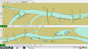
As early as 2011, in-innovative navigation GmbH already equipped the traffic center there with a VTS-System, in particular with a special split screen display, which for the first time made it possible to show the entire river section of the river through the city, including a lock and a bascule bridge, all on one single screen.
The traffic center of the responsible waterways and shipping authority, Rijkswaterstaat Limburg, is located about 500 m away from the lock, without direct view of the two bottlenecks, which makes the radar-based traffic display an essential tool there. Andreas Prizkau, project manager at in-innovative navigation GmbH: “We are very pleased that our IN System has proven itself in Maastricht and that we can now also modernize the system there. We will implement the new system this spring.”.
Split screen display of river Meuse inDTS:
Data communication at a new level
Inform yourself on the EUROPORT 2019 at booth no. 3303 about new possibilities of an extended display of the VTS traffic image. inVTS systems not only offer to display sensor data provided by sensors installed on mobile forces in a traffic control center; the data can also be shown in real time on mobile devices such as tablets using a standard web browser. This expands the range of options when using such data: Forces can inform themselves about the actual current situation regardless of their location.
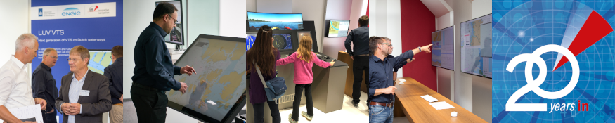
How these new functions and the product portfolio of in-innovative navigation GmbH will be implemented in the nationwide traffic monitoring system in the Netherlands (LUV VTS NL) in the future will also be shown on at booth no. 3303 at the EUROPORT.
The in-innovative navigation GmbH can not only provide services for coastal and offshore monitoring, but also new technologies for inland navigation, as shown in the RADARpilot720 ° NG (New Generation). The combination with argoTrackPilot (argonics) gives the skipper a new assistance system that automatically guides a ship along a guiding line.
We are looking forward to your visit!
20 years in-innovative navigation GmbH
The 20th anniversary of in-innovative navigation GmbH was the occasion for a two-day inHOUSE SYMPOSIUM & EXHIBITION entitled in FUTURE in MOTION. The President of the GDWS, Prof. Dr. Hans-Heinrich Witte, opened the conference. Numerous business partners and companions of in-innovative navigation GmbH from all over the world met in order to present the latest technologies and possibilities of digitization in the field of traffic monitoring and navigation. In a subsequent panel discussion, the chances of automation and digitization were discussed.
On the second day of the event, the latest practical developments were presented on an inHOUSE exhibition, where visitors were able to actively steer a vessel through the port of Rotterdam on a virtual ship bridge including state-of-the-art 3-D visualization. Also, the political guests as State Secretary Steffen Bilger of the Ministry of Transport and Dietmar Allgaier (Mayor of Kornwestheim) were impressed. In the evening of the second day, employees, their families and guests concluded the successful event with delicious grilled specialties, live music and dance.
Development and implementation of a modern Inland AIS system for the Donau River Information Service (DoRIS)
As part of the modernization of inland AIS communication on European inland waterways, the proven Austrian information and management system DoRIS (Donau River Information Service) will be extended. It has been operated by the viadonau since 2005 and serves both skippers and logistics providers, as well as authorities and the administration of the waterway as an important source of information about the traffic situation, water levels and lock waiting times. DoRIS prepares all information in a user-friendly way and makes it available via web portals, e-mail or as mobile apps.
viadonau has now awarded the contract to in-innovative navigation GmbH for renewal of this system with extension of the functionality scope. The new software is adapted to state-of-the-art technology and will meet the requirements of the international standardization panels. All data will not only be available at workstations in the traffic control center, but the data will also be presented via web technology on mobile devices.
Uwe Vögele, CEO of in-innovative navigation GmbH, confirms: “That was good news that just came right for Christmas. We are very proud that viadonau wants to carry on working with us for this forward-looking project in the area of Inland AIS. Thus, we can continue this exchange of experience, which was very fruitful for both parties in the past. “.