in-innovative navigation GmbH and CNIM Air Space have deployed two maritime airborne surveillance aerostat systems in Greece.
The project, for which both companies have joined forces in a consortium, with in-innovative navigation GmbH taking the lead, involves the delivery to FRONTEX of an integrated turn-key solution that comprises two tethered aerostats, for the purpose of testing the performance and cost-efficiency of these innovative solutions to maritime surveillance and awareness.
This concept offers an entire new and innovative approach, combining various surveillance sensors with a high degree of automation and a flexible, redeployable platform into a single comprehensive solution for persistent maritime surveillance. The deployment of the systems started in July and is planned to last a few more months.
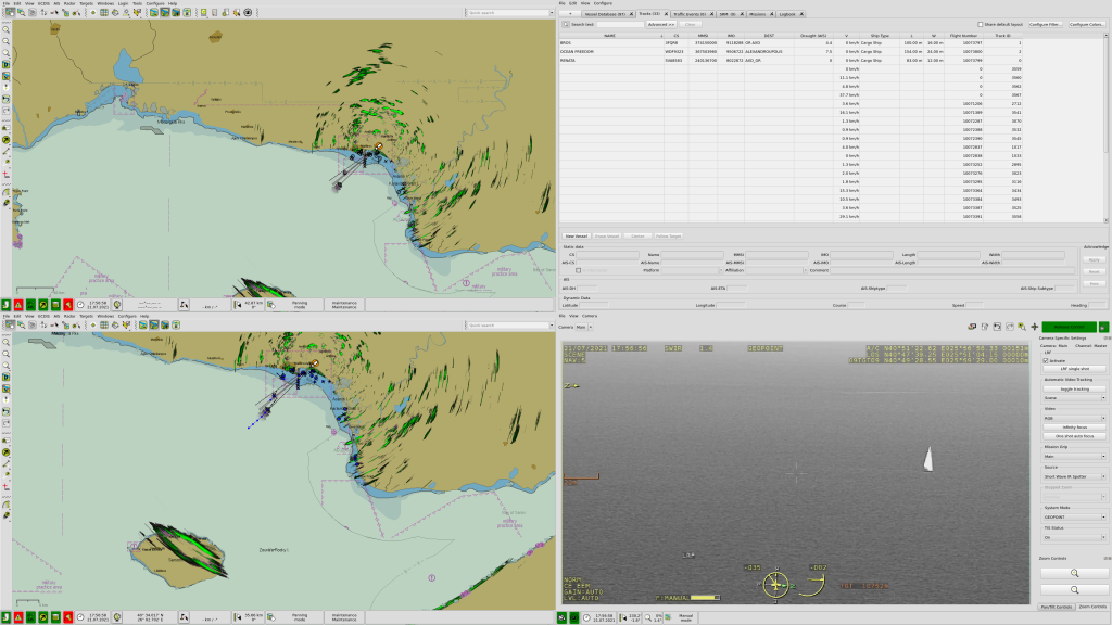
Each system is composed of a 450 m³ Eagle Owl tethered aerostat, equipped with a Hensoldt ARGOS II HD EO/IR optronic gimbal, a Diades Marine maritime radar, and an AIS receiver. The systems are contributing to the monitoring of maritime areas, and provide FRONTEX with the ability to detect, recognize and identify activities of interest. Each aerostat is accompanied by a ground station which is equipped with a C2 (Command & Control) workstation. The ground station, thus, controls the sensors, analyses the collected data, and transmits the most relevant information to FRONTEX operation centers. The system also allows the distribution of the maritime surveillance picture to any remote user through the use of web-based or mobile applications connected to the C2 system.
Airborne surveillance aerostat systems offer a number of advantages. Apart from the fact that it is a very cost-effective solution in terms of cost per operating hour compared to other airborne maritime surveillance systems, the other major added value of a tethered aerostat is its persistence. The system is designed to fly 24/7 for several days and even weeks. CNIM Air Space’s tethered aerostat solutions are mobile, easily movable and they don’t need a specific infrastructure to be deployed. The flight altitude of the tethered aerostat (hundreds of meters) offers another advantage. It frees the system from topography and earth curvature constraints, which usually limit the performance of standard ground systems. Finally, CNIM Air Space has managed to develop tethered aerostats which are threat resilient and adapted to a maritime environment (especially to strong winds, up to 110 km/h).
“Within the scope of this contract, CNIM Air Space is in charge of designing and manufacturing the Eagle Owl type tethered aerostats, embedding the sensors, setting up the ground segment and managing the operations of the complete system. Operations are led in partnership with Ventura Associates, a French security and defense operational expert.” explains Xavier Montazel, director of the Systems Business Line at CNIM.
Uwe Vögele, managing director at in-innovative navigation GmbH, adds “in-innovative navigation is in charge of integration, processing, validation and display of all data at the ground stations, as well as the communication interface between operations centers”.
“The award of this contract by FRONTEX demonstrates CNIM Air Space’s expertise in tethered aerostat systems. We are proud to deploy our solutions at a European scale” says Xavier Montazel.
“For in-innovative navigation, this award reflects FRONTEX’s continued confidence in our solutions and capabilities. It also proves that we have chosen the ideal aerostat partner to provide a comprehensive and high-quality system” concludes Uwe Vögele.
Display of integrated sensor information with inDTS at the ground station: